Roadtrip 2008: The GPS Track
Posted by:
o'wolf
17 years, 9 months ago
(0 comments)
I've finally visualized the GPS recording of the RV Trip with my parents last Winter. Unfortunately, LJ does not allow me to embed the interactive map, thus you have to click on this static one to play with it:
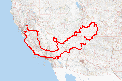
Some facts about the map:
- 4273354 GPS records logged in three weeks
- 930283 GPS positions logged
- 177717 GPS positions after eliminating errors, (nearly) identical positions and positions on straight lines
- That's far too much for real-time rendering, be it client or server side.
- Rendering the map at zoom level 18 took 28 minutes and 44 seconds and required 4 GB of memory
- Zoom level 18 has 49895 tiles and 201 MB of PNG data
- All zoom levels have 98682 tiles in total.
- Selectable layers: OpenStreetMap Mapnik, Osmarender and NASA Global Mosaic
Edit: doesn't work with IE6, though.
Comments
There are currently no comments
New Comment