Viewing posts by o'wolf
And here's a map of potential overflow hotels for Eurofurence, proposed by attendees:
With the growing amount of hotels available for Anthrocon guests it gets more difficult to keep track where exactly each hotel is located. Even for me, who's been attending Anthrocon for several years now. Thus, I've sat down and made an interactive map. Okay, to be honest, I wanted to do that for Eurofurence anyway, and it's fun to play with Openlayers 3... Please verify the phone numbers and street addresses in the popups (and send me corrections), as I might have missed some errors while cut and pasting the information at 1 am...
I'm up to 26 US states after this year's vacation:
MapQuest removed free access to their tile servers with one month of advance warning — and no, requiring an API key is not free access, especially not with an imposed usage limit.
I've made a new interactive map while I was playing with the GIS stuff again. This time to visualize the U.S. National Parks, National Monuments, National Recreational Areas, and National Seashores / Lake Shores I've visited over the last eleven years.
Look, it's a shiny new map! And even with two more US states I've visited:
This is a road trip after all, so let's hit the road and spontaniously decide to make a detour to Craters of the Moon National Monument. Okay, it wasn't that spontanious, we decided on that the night before, depending on how late we'd be in Idaho Falls. Actually, faster than we anticipated, so we drove through the arid rangeland of Snake River Plain until we reached the (cold) lava fields of Craters of the Moon. Interestingly, this is still considered being an active vulcanic area which lays dormant until the next eruption within the next 1000 years or so. It looks like a vulcano in Hawaii, but without the flowing lava. Is there any other place in North America like this? In any case, a strange area. Inferno Cone is basically a tall hill made of ash (a cinder cone), a trail leads to tree molds in a vast lava field, and we climbed through Indian Tunnel, a lava tube cave. No bats there, but the home of some feral pigeons that looked exactly like the Good Feathers...
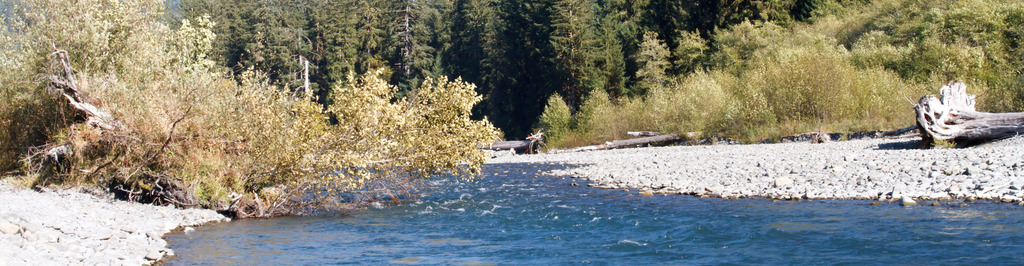
Yellowstone is great, but there is more in the area to see. Grand Teton National Park, for example. So we checked out in the morning, left the Yellowstone through South Entrance and took the scenic John D. Rockefeller Jr. Memorial Parkway (what a name) to Colter Bay at Jackson Lake. A short hike rewarded us with a great panorama of the mountain range West of the lake. And angry squirrels.